
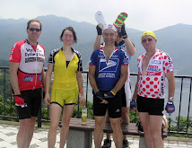
4 out of the 6 TCC riders finished in under one hour.
I was the slowest of the 6, finishing at 1:05:50, 296 out of 507 in the 40-49 group ("Road D" group). But for me this was a very good time, within 9 minutes of Thomas and Travis, whereas on the similar climb last week of O-Toge, I finished within 20 minutes of Thomas and 18 of Travis. And the 507 riders in the 40-49 group all looked like typical Japanese "climbers" -- very low body fat, pencil thin types, some tough as nails.
The route, up the "Toyo Tires Turnpike", a toll road usually normally closed to bicycles, involved a climb over 10 km from just above sea level (25m elev) to around 1000m elev., then 3.3 km of riding up and down hills along the top of a ridge, until one last uphill sprint to the finish. There is plenty of 13% grade, and several kilometers where the average grade is higher than 10%. I tried to keep a 10-11 kph speed even on the steepest stretches, and was pleasantly surprised that I could do so. Including the up and down sections along the ridge, the aggregate ascent is close to 1100 meters, much more than the Ekiden climb up Route 1 in Hakone.
After a brief rest at the top, my real ride began. Down to the lake -- Ashinoko -- and up and down small hills along its Southern shore, in heavy weekend tourist car traffic. It took longer than I expected to get to Sengokuhara, the flat-ish area at the East end of the lake, where the tourists were parking and hiking among the tall grasses.
 |
| Hakone, Sengokuhara, looking toward Otome-toge |
Then a short climb up Route 138 toward Otome Pass, through a tunnel, then down, down to Gotemba, and on the first plausible road I turned off of 138 and struck off to the N/NE through the valley toward the base of the next climb, Mikuni Pass, stopping at a convenience store for spaghetti and to check a map and make sure I could get to the climb without too many detours.
Mikuni was relentless, starting at below 500m elev and peaking at over 1150m elev, and much of the way 13-16% grade. At least it was reasonably cool. I got off the bike once for photos and some water when the "circular" pavement pattern appeared.
 |
| The dreaded circular pavement pattern. The grade was already crazy below here. Unlike most roads, it did not change noticeably when the circles appeared. |
I dismounted a second time higher up ... and needed to walk 100 meters or so up the hill and around a bend to find a place where I could actually manage to re-mount the bike and clip into my pedals safely.
 |
| The clouds got darker and darker, but we had dry roads all the way back to town. |
I met Jerome, who had ridden out to Yamanakako, and we enjoyed a fast trip down Doshi Michi and back into town in the failing light.
Around 175km and around 2500-3000m of climbing. At last I think I am fully recovered from PBP.


2 comments:
David, congrats again on your strong showing. Also, Mikuni must have been particularly tough having already gone full blast in the race. It's bad enough even otherwise.
I took it a bit easier on Saturday, but still managed to explore some new peaks (literally):
http://connect.garmin.com/activity/118224238
Post a Comment